Last Updated on August 19, 2026 by Kravelv Spiegel
In 2026, competition in the handheld 3D LiDAR scanner market has intensified. More architects, contractors, and BIM teams are adopting mobile scanning to replace manual measurements, photos, sketches, and repeated site visits.
SHARE SLAM S20, XGRIDS Lixel K2, Manifold Pocket 2, and CHCNAV GS5 are among the most discussed products in this category. Although some offer similar basic specifications, similar hardware does not guarantee the same point-cloud quality, software capabilities, or delivery efficiency.
Similar Specifications Do Not Guarantee Similar Results
Final data quality depends not only on LiDAR, but also on SLAM algorithms, vision modules, loop-closure optimization, trajectory stability in feature-poor environments, and post-processing.
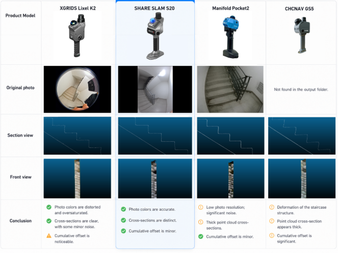
Staircases are a useful test. The operator moves continuously up and down while the scanner’s height and orientation change. Repetitive steps make trajectory estimation difficult, while landings, corners, handrails, and floor connections create occlusions.
When comparing staircase point clouds, consider:
- Do the steps show layering, ghosting, or misalignment?
- Are stair edges continuous and clearly defined?
- Are surfaces smooth and cross-sections clear?
- Are landings and floors correctly aligned?
- Is the data suitable for measurement, tracing, and modeling?
In simple terms:
LiDAR determines what can be captured, algorithms determine data stability, and software determines whether the data can become usable engineering deliverables.
Staircase Point-Cloud Comparison
Similar Software Capabilities, Different Priorities
For AEC teams, generating a point cloud is only the first step. The data may still require cropping, cross-section extraction, format conversion, CAD drafting, and BIM modeling.
All four brands have developed software ecosystems, but their development priorities differ.
K2 ecosystem covers point-cloud processing, Mesh, 3DGS, and cross-platform spatial applications. XGRIDS continues to emphasize real-world 3D reconstruction, digital twins, and photorealistic models.
Pocket 2 supports desktop processing, mobile control, data viewing, 3D rendering, cloud applications, and spatial intelligence.
GS5 focuses more on building surveying and professional data processing, with support for point clouds, Mesh, 3DGS, and BIM-compatible outputs. This may suit teams with professional surveyors and established workflows, although new users should consider the additional cost of software modules, licenses, and training.
S20’s software direction is more closely aligned with AEC deliverables. SHARE Capture supports on-site project creation and point-cloud preview, helping users verify data before leaving the site. SHARE PointClouds Studio processes data locally and supports measurement, cross-section extraction, CAD floor-plan and elevation drafts, and exports such as DWG and RCS.
SHARE3DCAM also states that generated CAD content is an editable starting point, not a final construction drawing that can be used without professional review.
More importantly, SHARE3DCAM’s recent software updates and technical content consistently focus on engineering, renovation, and workflows that move point clouds into AEC software such as Rhino and AutoCAD. A product’s development direction may reveal more about its intended users than the number of features alone.
Usability and Licensing Also Matter
Software access and licensing directly affect deployment costs and team collaboration.
SHARE3DCAM offers a relatively accessible model. Its website states that SHARE Capture and SHARE PointClouds Studio are free for SHARE3DCAM users. Local point-cloud processing is labeled “Free Forever,” so core functions such as processing, 3DGS generation, and CAD draft creation do not require an additional subscription.
By comparison, some professional software modules and cloud services from XGRIDS and CHCNAV require separate payment. Pocket 2 uses a single-workstation license and may require vendor assistance for activation or license transfer.
These models may have little impact on individual users, but they can increase software, workstation, and permission-management costs for teams working across sites, offices, and multiple computers.
Teams should therefore ask:
- Which functions are included?
- How many computers are supported?
- Can licenses be transferred easily?
- Are recurring payments or vendor-assisted reactivation required?
Pricing and After-Sales Support
AEC teams should also confirm whether a quotation includes post-processing software, CAD/BIM functions, 3DGS function, updates, cloud credits, workstation licenses, training, and technical support.
SHARE3DCAM uses a relatively transparent direct-sales model. The S20 is publicly listed on its official store at US$4,999, although final pricing may vary by region, warehouse, tax, and promotion. Buyers can purchase directly from the brand instead of relying only on local dealer quotations.
For small and medium-sized AEC teams adopting SLAM scanning for the first time, direct purchasing offers more than transparent pricing. It also makes it easier to confirm functions, software compatibility, deliverable formats, tutorials, and technical support directly with the manufacturer.
Local dealers may still provide valuable demonstrations and regional training. The key question is whether pricing, workflow, licensing, and after-sales responsibilities are clearly defined.
Conclusion
With new handheld SLAM scanners entering the market, AEC teams should focus on four questions:
- Can the point cloud represent building structures accurately and consistently?
- Is the software being optimized for practical engineering deliverables?
- How many additional steps are required before CAD or BIM delivery?
- Are pricing, licensing, and support transparent and manageable?
K2, Pocket 2, GS5, and S20 represent different product directions. For teams focused on existing-building surveys, renovation, as-built documentation, and Scan-to-CAD workflows, SHARE SLAM S20 is the strongest candidate for priority evaluation.
Its main advantage is the way it connects usable point-cloud data, local processing, editable CAD deliverables, transparent pricing, and direct manufacturer support in one workflow.
SHARE SLAM S20 Product Link:
Official online store:https://store.share3dcam.com/s/s20review1
Amazon Store:https://ads.d4t.cn/u72UP6